US National Park Service
Update - April 2004: With the release of Adobe Photoshop CS (v. 8), which now includes expanded support for 16-bit data, including layering, the DEM manipulation techniques described below are much easier to accomplish. In addition, Mac OSX users can export 16-bit DEMs from Photoshop 7.0 and CS in PGM format readable by Bryce using the free CartaPGM filter developed by Pascal Lamboley and Bernhard Jenny available here.
Resolution bumping is a technique in Adobe Photoshop for manipulating GTOPO30 and other small-scale digital elevation models (DEMs). The technique alters digital elevation surfaces in a manner that allows rugged mountains to be depicted more legibly and with a more natural appearance compared to unmodified data. Although resolution bumping is accomplished in Photoshop, the well-known image editing application, the technique is used solely for modifying raw elevation data prior to creating 3D scenes and shaded relief. Resolution bumping is not a post-rendering touchup procedure.
Problems with GTOPO30
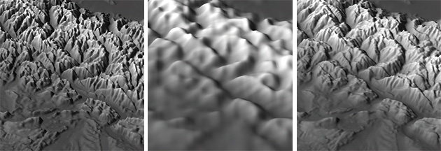
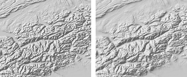
When used with 3D and relief shading applications, unmodified GTOPO30 typically produces mountains with a choppy appearance. Vertical exaggeration, which is a graphical necessity when making small-scale landscape depictions, exacerbates the choppiness. Especially problematic are glaciated northern mountains comprised of tightly packed ridges and valleys—for example, the Coast Ranges of British Columbia and the Alps, which often appear as an irregular texture rather than as recognizable topography. Solitary high peaks with small surface area, such as Mount Shasta or the Matterhorn, spike upwards like the Eiffel Tower. Topographic detail, vertical exaggeration, and small-scale presentation used in combination are the enemies of legible mountain depiction.
Downsampling GTOPO30 to a sparser resolution alleviates the problems outlined above. Generalized data is better for depicting patterns within mountain ranges and is more tolerant of vertical exaggeration. However, downsampling elevation data introduces new problems that are arguably worse than the original problems that were corrected. Knife-edged mountain ridges appear excessively rounded, like the vacuum-formed plastic relief maps used in schools, and simplified valley bottoms are prone to misregistration with drainages.
Resolution bumping: an overview
The idea behind resolution bumping is simple: by merging low-resolution and high-resolution GTOPO30 data of the same area, hybrid data are produced that combine the best characteristics and minimize the problems found in the originals. The technique uses GTOPO30 data in 16-bit grayscale format in Photoshop. Two copies of a GTOPO30 file are used, one high resolution and the other downsampled to a lower resolution, these can then be blended together by a proportional amount controlled by the user. This yields a new grayscale "DEM" that, if merged in the right proportions, combines the readability of the downsampled data with all the detail one expects to find in mountainous terrain—without the graphical noise. Resolution bumping in effect "bumps" or etches a suggestion of topographical detail onto generalized topographic surfaces. The resolution-bumped data creates an elevated base in mountainous regions, upon which individual mountains, with diminished vertical scaling, project upwards.

Using GTOPO30 in Photoshop
Instructions for obtaining and opening GTOPO30 in 16-bit grayscale format in Photoshop are available here.
Another option for Mac users is MacDEM freeware. GTOPO30 opened in MacDEM can be exported in binary format, which can then be opened in Photoshop as a raw (.raw) raster file.
When GTOPO30 opens in Photoshop it appears as a raster grayscale image with lighter pixels representing higher elevations and darker pixels representing low elevations. This graphical representation of relative height values has a negative ghosted appearance, somewhat like a medical x-ray, as opposed to raw GTOPO30, which is a text file of x, y, and z values. The ability to visualize raster GTOPO30 data spatially makes the resolution bumping procedure more comprehensible.
Resolution bumping requires that you import GTOPO30 data into Adobe Photoshop 5.0 or higher as a 16-bit raster grayscale file. Using 16-bit data is critical; the 65,000-plus levels of height information available at this vertical resolution allow terrain to be represented smoothly, as opposed to the 255 levels available in 8-bit data, which yields unacceptably coarse results.
Using 16-bit grayscale data in Photoshop has its handicaps. Much of Photoshop's functionality—layers, the clipboard, and most filters—are disabled, requiring workaround solutions based on the more limited tool set. Resolution bumping is made possible by using the rubber stamp tool to blend 16-bit data between two simultaneously opened images. Providing that the images have the same pixel dimensions, and that the sampling and receiving points are at precisely corresponding positions on both images, data can be transferred from one image to another in perfect registration. The blending mode (normal, multiply, darken, etc.) and blending opacity (measured in percent) of the transferred data are controlled by the rubber stamp tool options. Who needs layers?
Step-by-step instructions
1) Open GTOPO30 as a 16-bit grayscale image in a recent version of Photoshop. Save a copy of the file with a different name.
2) Downsample the resolution of the copied file. This is simple to do. In the drop menu go to Image/Image Size. Making sure that the resample option (lower left) is clicked, decrease the pixel dimensions (width and height) to 20 percent of the original size. The data has now been downsampled.
3) Next, you will increase the dimensions of the downsampled file back to its original size. For resolution bumping to work the downsampled GTOPO30 must have the same dimensions as its high-resolution counterpart. Increasing the dimensions of downsampled data does not restore information, it just makes the file size larger.
In the Image Size dialog, with resample resolution selected, increase the pixels dimensions by a reciprocal amount, which in this case is 500 percent of original size.
4) Open the original high-resolution GTOPO30 file alongside and to the left of the downsampled file. You will need to see the entirety of the downsampled file on the desktop; the upper-left corner of the high-resolution file is all that needs to be visible. Use the same magnification level on both files.
5) Double click on the rubber stamp tool in the toolbar to set the options. Set the mode to normal, opacity at 50%, and select the aligned option. With normal blending mode and the opacity set at 50%, the rubber stamp tool will combine the two GTOPO30 images at a 50:50 ratio. By comparison, 30% opacity would produce a 30:70 blending ratio with most emphasis given to the image receiving data.
6) In the brushes palette create a brush 300 (or more) pixels in diameter with a hardness of 100.
7) In Photoshop's Display & Cursors preferences (Command-K) select show brush size in the painting cursors sub menu. In a later step, as you clone data from one image to another, it is essential to see the area being canvassed by the rubber stamp tool.
8) Make sure that the info dialog is visible. You will need the x, y pixel coordinates for precisely positioning the rubber stamp tool when transfering data between images.
9) With high-resolution image active, place the rubber stamp tool at the extreme upper-left corner of the image until the info palette reports that x = 0, y = 0. Very carefully, press down the option key and click the mouse button once to sample data from this spot. If the cursor moves while doing this, repeat the process.
10) Activate the downsampled image window. Place the cursor over the x = 0, y = 0 position in the upper left corner. Click-hold the left mouse button to begin transfering data. Important: Do NOT release the mouse button until data has been transfered to the entire image. Systematically criss-cross the image as many times as necessary until the entire image has been covered. This is a little tricky because there is little visual difference between the data in the two images.
11) Save the image you just rubber stamped with a new name. Resolution bumping is completed!
12) Finally, import the resolution-bumped data (a conversion utility might be needed for this) into your favorite 3D or shaded relief application for final terrain rendering.
Downloads
You can use these prepared 16-bit grayscale Photoshop (.psd) files to experiment with resolution bumping. Centered on the Alps, the 1,024 x 1,024 (2MB) files are ready to use on either Mac or PC.
High-resolution
Low-resolution (downsampled from 1,024 x 1,024 pixels to 128 x 128 and back to 1,024 x 1,024)
Resolution bumped (a 50:50 mix of the two previous files)

--This chart shows the relationship between downsampling and blending opacity. The look of resolution-bumped GTOPO30 is dependent on the resolution of the downsampled host data and the percentage of blending with original high-resolution data. The best results, I find, are achieved with drastically downsampled host data (12.5 to 20% of original resolution) blended at about 50% opacity with the high-resolution data. When too little downsampling is used, or when the blending opacity is high, the resolution-bumped data does not appear to be appreciably different from unmodified data (see the examples on the right side of the chart). At the other extreme, data that has been downsampled by a large amount and blended lightly with high-resolution data yields topography that tends to look unnatural (see the examples on the left side of the chart).
--The blending modes in Photoshop behave differently with grayscale elevation data compared to the graphical images that we are accustomed to editing. Normal blending mode works best for merging elevation data with differing resolutions. Normal blending mode etches both positive (i.e. peaks) and negative (i.e. canyons) topographic detail on the downsampled host data below. By comparison, multiply mode only intensifies the darker negative values, ignoring positive topography. The converse is true for lighten blending mode. Additional experimentation with Photoshop's other blending modes could produce interesting, or even practical, results.
--Resolution bumping does not work well with large-scale elevation data. Unlike GTOPO30, showing large amounts of detail in large scale data is usually not a problem, rather it is a lack of detail that is of greater concern. The diminutive topographic features in GTOPO30 are much more tolerant of exotic data manipulation, such as resolution bumping, than large-scale DEMs where we possess real-world impressions about the look of the terrain. By contrast, few people have seen the Alps at 1:2,000,000-scale.
--Even at small scale, not all landscapes are suitable for resolution bumping. Most non-mountain topographic features (eroded drainages, tablelands, escarpments, foothills, etc.) appear quite nicely without data manipulation, even when large amounts of vertical exaggeration is used. Moreover, mountains that already have simplified forms, such as the fault-blocked Sierra Nevada, may not benefit from resolution-bumping.
--When resolution bumping is applied to GTOPO30 containing rugged mountains, the effect is also applied to adjacent lowlands, disproportionately generalizing the topography in these areas. Although lowland topographic generalization is often desirable, making these areas less cluttered for supporting additional non-topographic information, sometimes it is desirable to show full lowland detail while simultaneously applying resolution bumping to mountains. This can be accomplished by rubber-stamping data between images with a soft-edged brush only to mountainous areas in need of resolution bumping. Feeling adventurous?
--Wishing: Each new version of Photoshop in recent years has had greater 16-bit functionality. Perhaps, a new version of Photoshop will give us the ability to use layers with 16-bit data, which would make resolution bumping much easier to accomplish. Furthermore, resolution bumping need not be limited to Photoshop. The ability to downsample and merge elevation data, which is based on straightforward linear calculations, could be incorporated into dedicated terrain generation applications, presumably, with little trouble—maybe it has been done already.