Designing an Experimental Visitor Map of Grand Canyon's South Rim |
||
Tom Patterson |
||
US National Park Service, Harpers Ferry Center |
||
 |
||
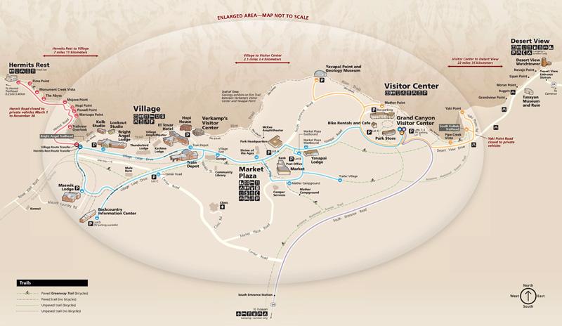
Orienting visitors to Grand Canyon's South Rim has been an ongoing challenge. Although maps are readily available in the brochure, seasonal newspapers, and on outdoor exhibits, park staff report that many first-time visitors still have a hard time getting around. To solve this problem, the park asked me to design a user-friendly “pocket map” aimed at the majority of visitors, who stay at the South Rim for four hours or less. Wi-Fi and cellular service are spotty at best, which ruled out mobile mapping solutions. The park initially suggested a map of Disneyland as design inspiration for the new South Rim map. The thinking went: who else has more experience efficiently guiding crowds through a destination park? We soon decided, however, that a Disneyland-style map was not applicable to the South Rim. Disneyland is a fabricated environment; the Grand Canyon is a natural one. Disneyland attractions are concentrated as opposed to South Rim points of interest found over tens of miles. And the pictorial style of the Disneyland map is incompatible with the clean, Swiss-inspired look of National Park Service maps. The map that I designed is a hybrid—part classic National Park Service map and part transit map. I treated scale elastically with larger scales given to places with concentrated visitor facilities, such as Grand Canyon Village, and smaller scales given to outlying areas. I depict roads, bus routes, and trails in a semi diagrammatic fashion, a trait borrowed from transit maps, which increases legibility of congested areas. The printed map is 16.5 inches wide. Designing an outwardly simple final map was not simple to do. Working intermittently, the South Rim map took five months to complete. Putting the map aside for weeks at a time allowed me to critique it with a dispassionate eye. My design progress was iterative; I saved 27 versions of the map to my hard drive. The park will evaluate the map's effectiveness during the winter of 2015-16, by asking for comments from rangers, bus drivers, and others in direct contact with visitors. I will then modify the design and update content. If successful, the new map with visitor information on the reverse side, used in conjunction with a redesigned interpretive brochure, will eventually replace the multi-page park newspaper. I would next create a similar map of the less-visited North Rim. |
||