Making 3D Terrain Maps |
||||||||||||||
--Water: Reflections and Waves |
||||||||||||||
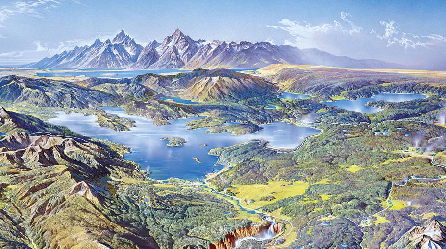
Austrian Heinrich Berann (1915-99), the most talented and prolific panoramist of the manual era, considered water bodies as special places on 3D terrain maps. Lakes in the Yellowstone scene below typify the lavish attention Berann gave to water. Bright blue and shimmering jewel-like in the high-altitude sun, Yellowstone's lakes attract our attention with wind ripples, reflections, near shore shallows, and even motorboat wakes. They bring drama and life to an otherwise static landscape. |
||||||||||||||
 |
||||||||||||||
Yellowstone panorama by Heinrich Berann (1991). The scene looks south across Yellowstone Lake toward the Teton Range. (Click map to enlarge.) |
||||||||||||||
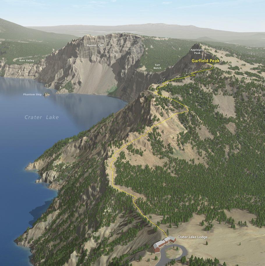
3D terrain software allows us to create eye-catching water bodies that resemble those painted by Berann—without the boats. I created the scene below of Crater Lake with Natural Scene Designer Pro. The lake surface started out as an aerial photograph draped on a digital elevation model. The aerial photograph captured the deep blue of Crater Lake transitioning to shallows in a narrow band adjacent to the shore. (The shallows are noticeable in the left foreground of the scene.) But what makes the lake come alive is the reflective surface added on top of the aerial photograph. In Natural Scene Designer Pro, I simply selected the "Create a Lake" tool and then clicked on Crater Lake in the Map Window to fill it. The end result is a lake surface that reflects the mountainous far shore. Specifying a three-centimeter wave height created diffuse reflections (Settings/Water/Wave Height). The slight transparency of lake surfaces in Natural Scene Designer Pro reveals the aerial photograph below, such as near shore shallows. |
||||||||||||||
 |
||||||||||||||
Garfield Peak Trail, Crater Lake National Park, Oregon. (Click map to enlarge.) |
||||||||||||||
 |
||||||||||||||
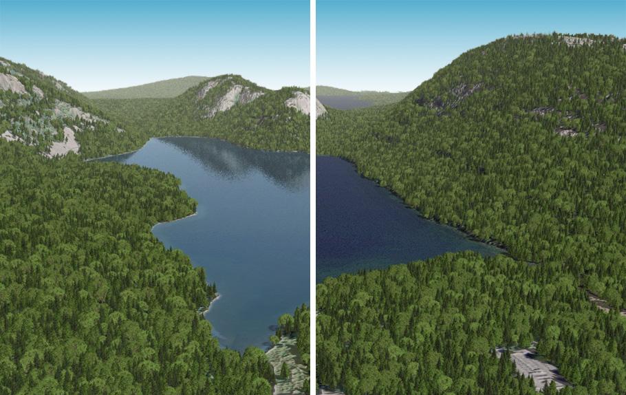
Jordan Pond, Acadia National Park, Maine. The left image has a reflective lake surface and the right image does not. |
||||||||||||||
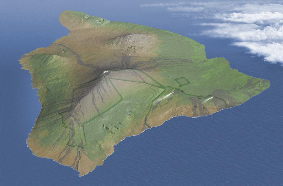
Comments • If your scene has both background trees and lakes, like the Acadia example above, Natural Scene Designer has a convenient feature that prohibits trees from growing in the lakes. • Crater Lake was very easy to fill with the "Create a Lake" tool because it does not have an outlet. Jordan Pond, which has an outlet, was a different story. To prevent the lake surface from spilling through the outlet and filling all of the valley downstream, I drew a low dam across the outlet with the "Edit terrain" tool in the Map Window. This gets tedious if your scene contains many lakes. • By far the biggest problem with the "Create a Lake" tool is when the draped aerial photograph and the digital elevation model below it do not align. You can end up with dry land that is reflective and lakes that are not. There are two ways to work around this problem. I recommend Photoshop touchups when the misalignment is slight. Severe cases, however, require manually editing the lake area on the digital elevation model to match that of the aerial photograph. I do this in Photoshop with Avenza's Geographic Imager GIS plug-in using a procedure too complicated to explain here. Making waves Natural Scene Designer Pro, which is fine for adding small ripples on lakes, would not impress big wave surfers. Producing ocean waves with crests and troughs is not possible. To get around this limitation, I render realistic wave textures in Vue, which I add to my scenes in Photoshop. The Hawaii scene below, for example, uses one of these wave textures, which you can download by clicking here. Waves are integral to the scene. Northeast trade winds drive the waves; a wind direction matched by the dispersing volcanic plumes on land. Light emanating from the southeast highlights both the wave crests and mountain peaks. Waves are absent from the protected lee shores (on the left side). A thin surf line that I drew in Photoshop is visible on foreground shores. Wave size diminishes from foreground to background to reinforce the sense of depth within the scene. And I added a sprinkling of white caps in the roughest seas (on the bottom right). |
||||||||||||||
 |
||||||||||||||
Big Island, Hawaii. To illustrate waves on this small-scale map, I had to make them disproportionately large—several kilometers in length! |
||||||||||||||
 |
||||||||||||||