Making 3D Terrain Maps |
||||||||||
--Camera: Pitch |
||||||||||
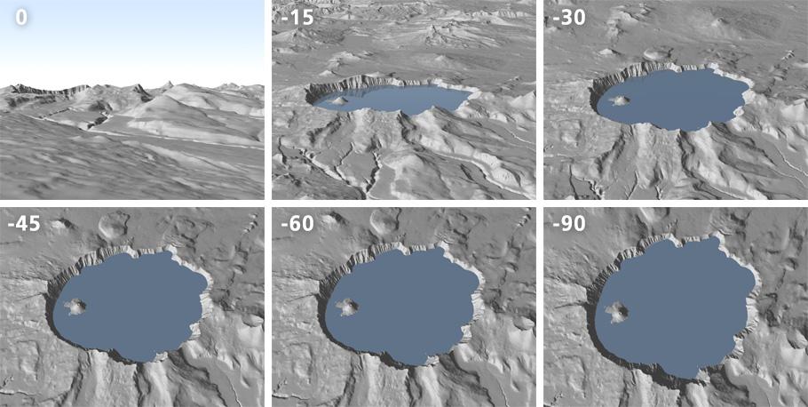
Viewing a place at an oblique angle from above is what fascinates us most about 3D terrain maps. In Natural Scene Designer Pro, Pitch controls the downward tilt of the virtual camera used to view the terrain (see illustration below). At 0° pitch the camera is horizontal. With this setting and from a low altitude, the rendered scene would look similar to what a person sees while standing on the ground. At -90° pitch the camera is vertical. With this setting and from a high altitude, the rendered scene would look indistinguishable from a conventional map. To make a 3D terrain map, the trick is finding an ideal pitch setting somewhere between these extremes. |
||||||||||
 |
||||||||||
Camera pitch study, Crater Lake, Oregon. Shallow angles are where the action is. Changing the pitch from -15° to -30° has more noticeable influence on the view than from -60° to -90°. |
||||||||||
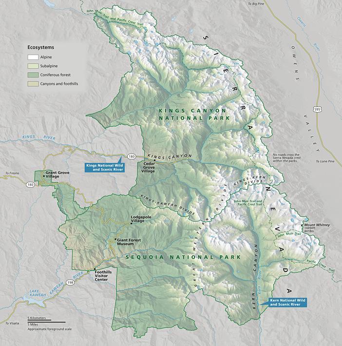
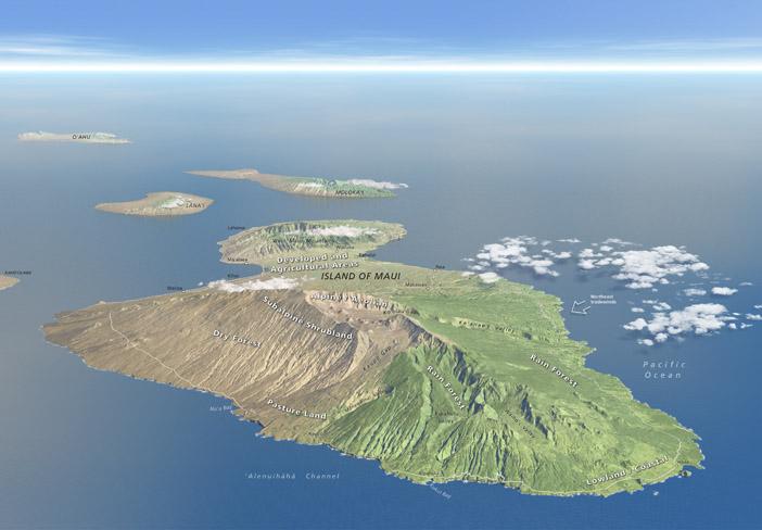
The choice is between dramatic terrain at shallower pitches and more map-like scenes at steeper pitches. As a cartographer, my first priority is to clearly show spatial relationships on the terrain surface. At the same time, I strive to create a scene that presents the terrain with considerable drama. Increasing the terrain vertical exaggeration can compensate somewhat for steeper pitches that I prefer. Of the seven 3D terrain maps that I am currently working on, the average pitch is -37°. Terrain characteristics often dictate camera pitch. The map of Sequoia and Kings Canyon National Parks below uses a steep pitch to show Kings River and Route 180 deep within Kings Canyon. At shallower pitches the river would be completely hidden. The narrowing shape of the parks from south to north was another factor. At shallower pitches the northern apex would be very far away. The second map below of Maui, Hawaii, employs a shallow camera pitch to emphasize Haleakala (the shield volcano in the foreground) that otherwise would look inconsequential because of its gradual slopes. The protruding West Maui Mountains in the background obscure parts of the island unimportant to the map's purpose. By contrast, in the foreground, Haleakala's eroded valleys slope from summit to sea, tilting toward the reader. |
||||||||||
 |
||||||||||
A high oblique view of Sequoia and Kings Canyon National Parks, California, with the camera pitch set at -46°. (Click map to enlarge.) |
||||||||||
 |
||||||||||
A low oblique view of Maui, Hawaii, with the camera pitch set at -12°, which is low enough to show the horizon. (Click map to enlarge.) |
||||||||||
Camera pitch causes foreshortening, the compression you see from foreground to background in a scene, which is sometimes useful for layout purposes. Take for example the California Trail map below. This primarily east-west trail has western branches going as far north as Salem, Oregon, and as far south as the central Sierra Nevada. Fitting the map on an A12 sheet of paper was only possible by rendering it as a 3D oblique view, which lessened the height. |
||||||||||
 |
||||||||||
The California Trail. (Click map to enlarge.) |
||||||||||
Plan Oblique Relief To make a map with the steepest possible camera pitch, consider the Plan Oblique Relief rendering option in Natural Scene Designer Pro. Refer to this article for information about this unique type of map. |
||||||||||
 |
||||||||||