Making 3D Terrain Maps |
||||||||||||
--Camera: Lens (focal length) |
||||||||||||
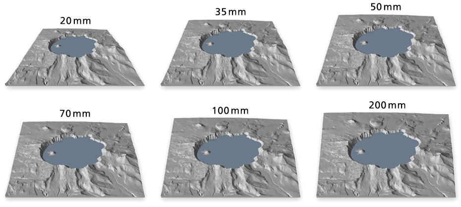
Changing this sometimes forgotten camera setting—in Natural Scene Designer Pro, the tendency is to stay with the default 35-millimeter lens—will greatly alter the appearance of your final map. The illustration below shows a sampling of the choices available, from a very wide-angle 20-millimeter lens to a very telephoto 200-millimeter lens. Wide-angle lenses result in scenes with considerable perspective convergence; the foreground is magnified and the background pinches toward an unseen vanishing point. By contrast, telephoto lenses have less perspective convergence; the foreground and background are similar in size. |
||||||||||||
 |
||||||||||||
Camera lens study, Crater Lake, Oregon. The camera pitch is a constant -35° for all scenes. |
||||||||||||
I prefer telephoto lenses to wide-angle lenses for general mapmaking. I start by setting up a scene with a 70-millimeter lens and then change the focal length as needed. Besides depicting the foreground and background more equal in size, telephoto lenses are better suited to making maps that must fit within a rectangular formatted shape (see illustration and Chiricahua map below). |
||||||||||||
 |
||||||||||||
Map in a box: Compared to a wide-angle lens (left), the same data rendered with a telephoto lens (right) completely fills the red bounding box. |
||||||||||||
 |
||||||||||||
Chiricahua National Monument, Arizona, rendered with a telephoto camera lens and steep camera pitch. With these settings the distinctive park shape remains recognizable on the up-and-down terrain (Click map to enlarge.) |
||||||||||||
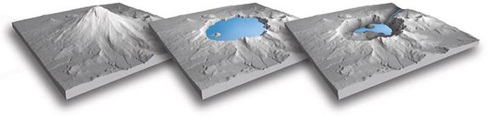
Despite my preference for slightly telephoto 3D terrain maps, they are not problem free. The lack of optical perspective can result in boring scenes with little foreground to background depth. To counteract this, I will add background haze, foreground shadows, valley fog, and clouds, which I discuss on a later page. I tend to use wide-angle-lenses for making geology block diagrams and illustrative maps with few labels and lines. For example, the Crater Lake block diagrams below looked more dynamic—as are geologic processes—when rendered with a wide-angle lens. Using a partial side view adds to the visual interest. |
||||||||||||
 |
||||||||||||
Crater Lake geology: (left) Ancient Mt. Mazama, a stratovolcano. (Middle) The lake today. (Right) Possible future breaching of the caldera wall. |
||||||||||||
 |
||||||||||||