Making 3D Terrain Maps |
||||||||||
--Vertical Exaggeration |
||||||||||
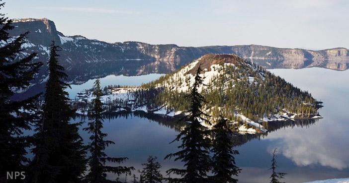
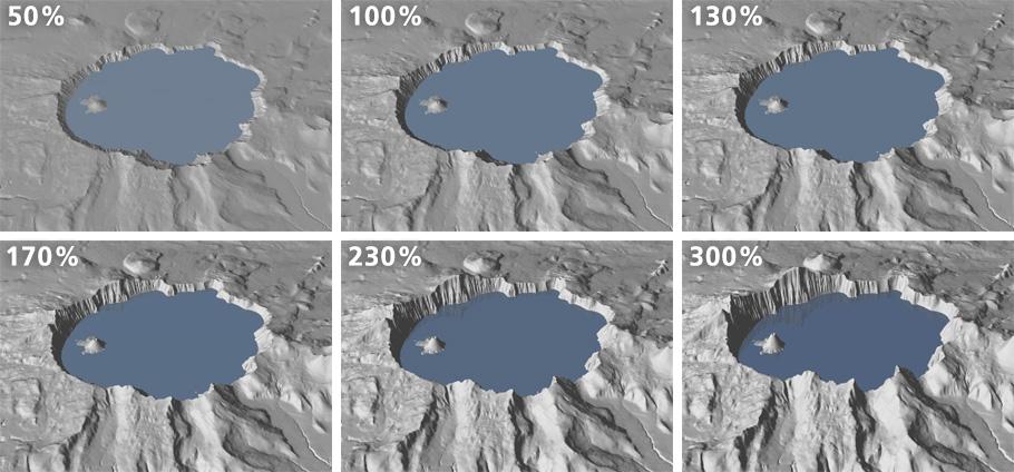
Applying at least a small amount of vertical exaggeration to 3D terrain maps helps them appear more natural. Selecting how much vertical exaggeration to use ultimately depends on what looks right to you. Too little vertical exaggeration can result in unduly flat terrain. Too much vertical exaggeration can distort terrain to the point of misrepresentation. The trick is finding something in between that is just right. Ideally, I like vertical exaggeration on the map to match how we see (or remember) a landscape while in it. For example, Wizard Island in the photograph below looks more imposing from the rim of Crater Lake than it does on a small-scale map. Which of the maps below the photograph best captures how it looks? |
||||||||||
 |
||||||||||
Wizard Island from the west rim of Crater Lake. |
||||||||||
 |
||||||||||
Vertical exaggeration study, Crater Lake, Oregon. A consistent camera pitch (-40°) and camera lens (70 mm) was used. Note the more contrasting tones that occur with greater vertical exaggeration. |
||||||||||
Vertical exaggeration advice • Although it is possible to do, I have never made a 3D terrain map with vertical exaggeration less than 100%. What would be the point? • On the other hand, when in doubt, use slightly less vertical exaggeration rather than more. For most maps, boring is better than freaky. • Extremely high and steep terrain, such as the Matterhorn, may not require additional vertical exaggeration (beyond 100%), especially at large map scales. • Small-scale elevation data and maps need increased vertical exaggeration compared to large-scale maps. On a North America map, the Colorado Rockies would look diminutive without pumped up vertical exaggeration (see illustration below). • Smoothed or generalized elevation data accommodates vertical exaggeration better than detailed elevation data, which can become spiky with too much vertical exaggeration. • At the same map scale, flat places need more vertical exaggeration than would mountainous places. For instance, the subtle terrain of Florida needs considerable vertical exaggeration in order to be seen. • Consider using vertical exaggeration on maps intended to warn people of steep trails and dangerous heights. The Grand Canyon exemplifies this: hikers venturing into the canyon are faced with a steep, hot climb to get back out. • You needn't rely completely on vertical exaggeration to make mountains "pop" off the page. Modest vertical exaggeration combined with illumination highlights, hypsometric tints, or land cover can enhance the apparent 3D effect. |
||||||||||
 |
||||||||||
A one-kilometer DEM of the southern Rocky Mountains rendered with varying amounts of vertical exaggeration. Small-scale terrain requires more vertical exaggeration than large-scale terrain. |
||||||||||
 |
||||||||||