 |
 |
 |
 |
 |
 |
||||||||||||
|
Natural Earth III – Texture Maps
|
|||||||||||||||||
|
|
|||||||||||||||||
|
1. Deluxe: Earth with edited clouds
|
|||||||||||||||||
|
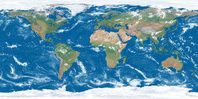
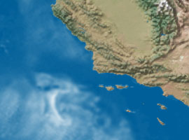
Full coverage |
Detail (S. California) |
||||||||||||||||
 |
 |
||||||||||||||||
|
Download:...16,200 x 8,100 JPEG (46.7 MB)......8,192 x 4,096 JPEG (17.5 MB) |
|||||||||||||||||
|
|
|||||||||||||||||
|
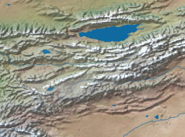
Full coverage |
Detail (Tien Shan, Central Asia) |
||||||||||||||||
 |
 |
||||||||||||||||
|
Download:...16,200 x 8,100 JPEG (30 MB)......8,192 x 4,096 JPEG (9.1 MB) |
|||||||||||||||||
|
|
|||||||||||||||||
|
3. Earth without clouds or Arctic Ocean ice
|
|||||||||||||||||
|
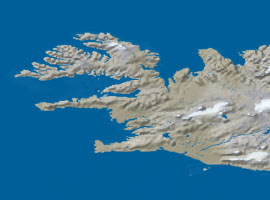
Full coverage |
Detail (W. Iceland) |
||||||||||||||||
 |
 |
||||||||||||||||
|
Download:...16,200 x 8,100 JPEG (28.7 MB)......8,192 x 4,096 JPEG (8.3 MB) |
|||||||||||||||||
|
|
|||||||||||||||||
|
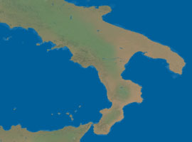
4. Basic: Earth without clouds, Arctic Ocean ice, or shaded relief
|
|||||||||||||||||
|
Full coverage |
Detail (S. Italy) |
||||||||||||||||
 |
 |
||||||||||||||||
|
Download:...16,200 x 8,100 JPEG (26.5 MB)......8,192 x 4,096 JPEG (7.4 MB) |
|||||||||||||||||
|
|
|||||||||||||||||
|
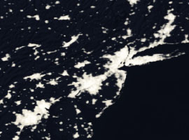
Full coverage |
Detail (New York) |
||||||||||||||||
 |
 |
||||||||||||||||
|
Download:...16,200 x 8,100 JPEG (14.9 MB)......8,192 x 4,096 JPEG (4.4 MB) |
|||||||||||||||||
|
|
|||||||||||||||||
|
About the texture maps
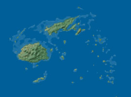
Natural Earth III textures derive from Natural Earth II, a previous map dataset depicting world environments and terrain with natural colors. Compared to Natural Earth II, the colors on Natural Earth III are darker and less contrasting to better match the appearance of Earth in photographs taken from space—up to a point. High altitude Earth photographs typically suffer from legibility problems. For example, humid regions with considerable vegetation (the places where many of us live) tend to be dark, drab, and lacking in detail. To remedy this, land on Natural Earth III is more colorful, and both the land and ocean are several shades lighter than photographs. New features in Natural Earth III include coral reefs and sediment plumes extending into the ocean from major river mouths. The coral reefs, which appear pale blue against the dark blue of deeper adjacent waters, derive from manipulated SRTM30 Plus bathymetric data that indicate shallow water only a few meters deep in tropical seas. Sediment plumes were extracted from NASA's Blue Marble satellite image and include manual enhancements with the airbrush tool in Photoshop. |
|||||||||||||||||
|
Coral reefs (Fiji) |
Sediment plume (Nile delta) |
||||||||||||||||
 |
 |
||||||||||||||||
|
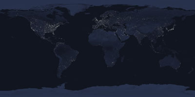
The base image for Earth at night (texture map 5, above) is a darkened and desaturated version of texture map 2. The city lights primarily derive from NASA's Earth's City Lights image. In this remotely sensed image, urban areas everywhere are exaggerated in extent and glow as brightly as Las Vegas, which make for eye-catching night scenes. AVHRR urban land cover data added to the NASA image brings even more brightness to the centers of large cities. |
|||||||||||||||||
|
|
|||||||||||||||||
| Projection and georeferencing Download:...Projection information and world (.tfw) files (4 KB) |
|||||||||||||||||
|
|
|
|
|
|
||||||||||||